
Background
Climate changes and the ongoing intensification of agriculture effect in increased material inputs in watercourses and dams. Especially, soil erosion causes sediment inputs that pose a risk for water protection and the quality of drinking water. Thus, water industry associations, suppliers and municipalities face new challenges. To ensure an efficient and environmentally friendly water supply for the future, adjustments on changing conditions are necessary. There is a need for water management monitoring programmes in order to develop methods to reduce pollutant inputs into surface waters. In addition, the project focusses on the usability of open access big data in combination with in-situ data for the purpose of analysing and predicting heavy rain events. In this context, the research project WaCoDiS contributes to the challange of reducing pollutant discharges and inputs, in order to come up with solutions for fertilizer planning and agricultural measures which can subsequently be implemented in cooperation with the farmers.
Goals
The research project WaCoDiS aims to geo-locate and quantify material outputs from agricultural areas and to optimize models for sediment and material inputs (nutrient contamination) into watercourses and dams. This enables both the localizing of pollutant sources and the development, realization and monitoring of case specific measures for water protection. Therefore, different data sources like Copernicus satellite data and in-situ data, existing web services and novel domain model components will be combined.
The application to be developed will be deployed in an operative test mode within the infrastructure of the Wupperverband, a regional German water management association, in order to identify sediment transport paths and sources and to optimize monitoring processes for its dynamic catchment area. In addition, the project evaluates the usability of open access big data in combination with in-situ data for the purpose of analysing and predicting heavy rain events.
The application to be developed will be deployed in an operative test mode within the infrastructure of the Wupperverband, a regional German water management association, in order to identify sediment transport paths and sources and to optimize monitoring processes for its dynamic catchment area. In addition, the project evaluates the usability of open access big data in combination with in-situ data for the purpose of analysing and predicting heavy rain events.
Area of Study
The system architecture will be tested and comprehensively validated for the 813 km² catchment area of the Wupper in Germany. For this region, the Wupperverband, which is also practice partner in the project, is the responsible water authority. Thus, existing water management monitoring processes can be optimized especially with regard to water pollution control and water protection. In addition, a feasibility study examines to what extent analysis and prognosis of heavy rain events can be optimized on the basis of freely available mass data (Big & Open Data) in combination with in-situ data. This will enable the damage potential to be estimated and ultimately minimized in the future.
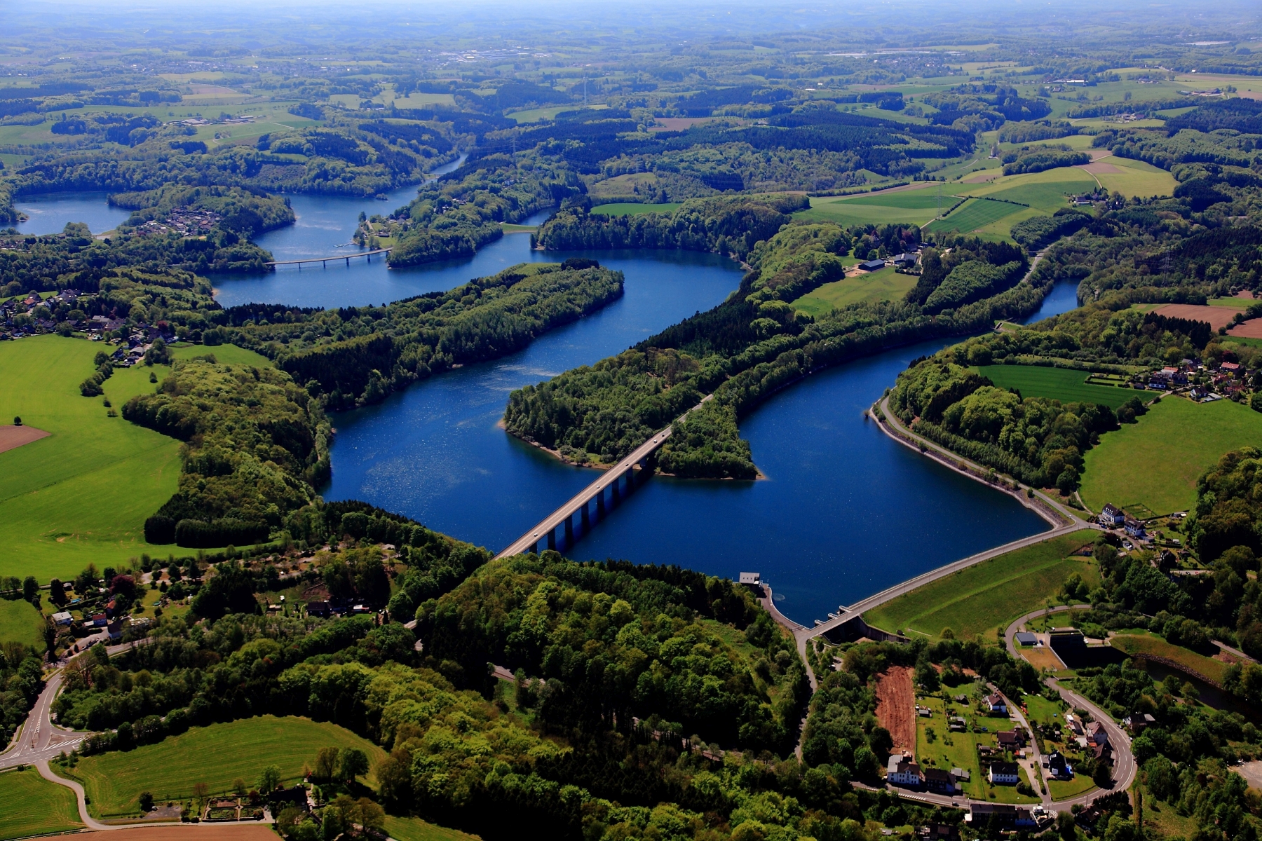
Wupper-Talsperre (Source: Wupperverband, Author: Peter Sondermann, 2017)
Technical Concept
As part of the project, technical solution for the implementation of an improved software-independent water monitoring will be developed. This concept mainly includes the following aspects:
- Integration of temporal high-resolution remote sensing data (Copernicus, German Weather Service) into the existing SDI of the Wupperverband on the basis of standardized interfaces and technologies (Sensor Web and geodata services such as the FluGGS)
- Interoperable combination and analysis of different satellite datasets (e.g. land cover, soil parameters, meteorological parameters) and heterogeneous sensor data with different spatial-temporal resolutions (e.g. digital orthophotos, image data of cameras and drones, digital elevation models and in situ components such as water quality parameters and meteorological parameters)
- Generation of information products and development of innovative environmental analysis services from the combined and automated processing of Sentinel-1 and Sentinel-2 datasets (e.g. intra-annual variability of the soil nutrient balance, vitality of the vegetation)
- Improvement of domain-specific (hydrological and limnological) models for the simulation of material input flows (erosion, sediment transport)
- Development of case-specific measures for water protection, which can be implemented in future in cooperation with farmers
Afterall, the developed water management analysis services and models can be integrated into domain-specific applications that can be used by business users for optimizing process workflows.
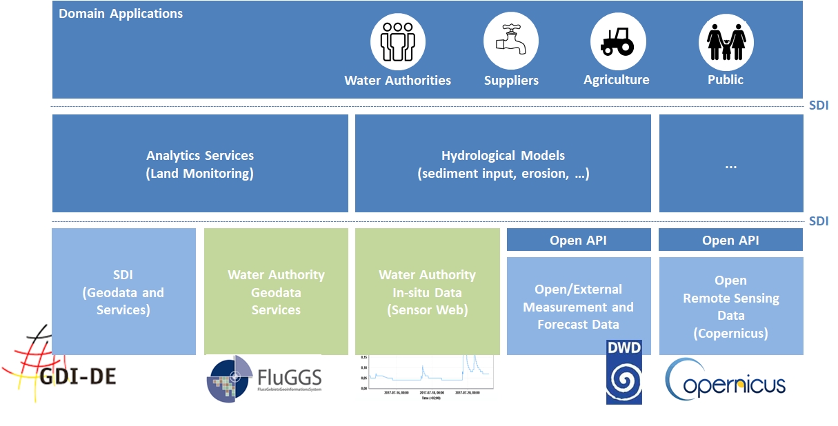
Tehnical Concept for WaCoDiS
Innovation
Innovative Earth Observation Products
By a combined analysis of satellite data and other in-situ measurement data, a precise spatial and up-to-date localization ofe material inputs and an optimized modeling of the sediment transport and pollutant flows becomes possible for the first time. The potential of a combined analysis of the Sentinel-1 and Sentinel-2 datasets will be used to derive information about the land cover and its dynamics as well as information about the intraannual variability of soil moisture and soil nutrient balance (eg soil nitrate and phosphorus). In addition, relevant meteorological data from the DWD (satellite data and in-situ data) will be included in order to validate the statements on soil moisture and to improve the analysis of the effects of heavy rainfall events at the operational level. On this basis, case-specific measures for water protection can be developed and be implemented in the near future in cooperation with the farmers.
Automatic Processing of Big Data
WaCoDiS takes advantage of current developments in the field of interoperable system architectures and the availability of satellite remote sensing data to develop direct access to and integration of satellite data into an existing SDI, which also enables the direct processing of big data. A micro-service-oriented and event-driven system architecture enables the implementation of automated processing workflows. There is also the opportunity to prepare the WaCoDiS system architecture directly for a connection to the Copernicus Data Platform Germany (CODE-DE), which is currently being set up.
Interoperable and Standardized Monitoring Services
Finally, an innovative, web-based monitoring tool will be available, which will be extensively validated within WaCoDiS in various water management fields for the preparation of operational use. The modular software architecture also enables an easily adaption of the application to other areas and to use it as the basis of component-based software. By using standardized interfaces (e.g. OGC Web Coverage Service (WCS), OGC Web Processing Service (WPS) as well as OGC Sensor Web Enablement (SWE) standards), sensor data from other departments dealing with environmental monitoring issues can be integrated into this web-based system independently in order to provide the integrated domain related information to a wide range of users in a timely manner.